LegalServer Integrates GIS
LegalServer releases customized GIS mapping and reporting tools for the web-based case management software used by thousands in the legal aid community.
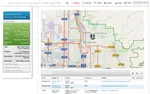
The GIS Reporting and Tracking Module allows organizations to visualize case data like never before with these new advanced mapping features. The module allows organizations to add GIS reports with custom filters, multiple data types and timeline trend analysis.